| Ron Hess Home Page | Projects | Professional Summary | Active Mines Map |
Last update 10/23/25.Table of Contents: Nevada Mining, Prospecting, and Mineral Resource Projects Older References to Geology, Prospecting, and Mineral Resources Oil, Gas, and Geothermal Projects Earthquake Hazard Reports Other Projects, Topographic Maps, and Additional Resources Nevada Mining, Prospecting, and Mineral Resource Projects:
Nevada Active Mines and Energy Producers NBMG Map 170 available as a 46 Mb size pdf file, a reduced size pdf is also available by clicking here. For the complete GIS data set for this map click here (104 Mb zip file). NBMG Open-File Report 10-5, a version of the above map that includes mining district names is available at full resolution (46 Mb file size) and can also be viewed in a reduced file size by clicking here.
NBMG Online Mining District and Historic Mining Information Files with Search Engine, 2nd edition, 2010: Nevada Bureau of Mines and Geology, Open-File Report 10-8, for online search engine and additional documents click here. This data collection, of over 25,000 documents and maps, contains a variety of historic and current mining and mineral resource related information about Nevada. This data collection can be searched online and it works best on a high speed connection due to the large file size of the scanned documents and maps.
Metal Mining Districts of Nevada, Map 37, by John Schilling, 1976. This image is of the 3rd edition which is out of print. Map 37 has been superseded by NBMG Report 47, Mining Districts of Nevada, 1998, and the map of Nevada Mining Districts from Report 47. An untitled map of Nevada Mining Districts, dated 1946, is also viewable as a large Acrobat pdf file. A 1932 NBMG report, with map, on Nevada Mining Districts entitled Metal and Nonmetal Occurrences in Nevada can also be viewed. U.S. Geological Survey Open-File Report 83-721, is a preliminary report that identifies mineralized areas within Nevada. A 1912 report entitled "The Mining Districts of the Western United States" U.S. Geological Survey Bulletin 507 by James Hill with a geologic introduction by Waldemar Lindgren (32 Mb PDF file).
The Nevada Abandoned Mine Lands (AML) Database Update, Nevada Bureau of Mines and Geology, Open-File Report 2001-03, is available online as a large zip file - 117 Mb. The goal of this project was to compile and update existing digital datasets containing mine information and site location data on over 100,000 mine and prospect sites throughout the State of Nevada. These digital datasets are in shapefile format and dBase III+ file format. All UTM coordinates associated with this project are in zone 11, meters, NAD 27 projection. This compilation effort concentrated on four primary datasets: Selected items from the U.S. Bureau of Mines Minerals Availability System/Mineral Industry Location System (MAS/MILS) database (USGS Open-File Report 98-512) originally produced by the U.S. Bureau of Mines; the Mineral Resources Data System (MRDS) database (USGS Open-File Report 99-169) produced by the U.S. Geological Survey; the Nevada Division of Minerals Abandoned Mine Database; and the Nevada Bureau of Mines and Geology Open-File Report 96-4 prospect/mine site point file. This last dataset set was digitized from USGS topographic maps and consisted of mine, prospect, shaft, and quarry locations. Nevada Abandon Mine Lands (AML) Project, Map of the Reno, Nevada area showing some of the data compiled during the AML project.
Compilation of USGS MRDS and USBM MILS mine and prospect data bases into a short version with selected fields in dbase III format. Site locations are in UTM, zone 11, meters, NAD27 projection. Mine name and location accuracy are dependent on the original MRDS and MILS data and can vary significantly from the existing property name and actual location. To see a listing of the data base indexed by site name click here . To see a list of the data base indexed by the topographic map name (note quad location index maps below) that the site is located on click here . To download the dbase file (pkzipped and approximately 1 megabyte in size) click here. Historic, 1960, USGS Topographic Map Index of Nevada, showing existing older USGS 7.5 minute, 15 minute, 30 minute, and 1 degree map names and outlines. Newer index from 1984, USGS Topographic Maps of Nevada, showing more USGS 7.5 minute, 15 minute, and 1 degree map names and outlines. More current index from 1997, Primary Series 1:24,000 Scale Topographic Map Index of Nevada, showing only USGS 7.5 minute map names and outlines.
Google Map KML file compilation for the Nevada Petroleum and Geothermal Society Google Earth Technical Workshop: Reno, Nevada, March 21, 2013. Click here for a zip compressed file containing some of the Nevada mineral resource, oil, gas, geothermal, and geology files converted to Google Map KML format along with other referenced Web links discussed at the workshop (17 Mb zip file).
Older References to Geology, Prospecting, and Mineral Resources:
Bulletin 36, Nevada's common minerals (including a preliminary list of minerals found in the state), by Vincent P. Gianella, 1941. A large table, Identification of Nevada's Common Minerals, from Identification of Nevada's Common Minerals, Bulletin 22, by Oliver Grawe, 1928, in pdf file format. This publication was a predecessor to Bulletin 36. JPEG file version of Nevada's Common Minerals table. Bulletin 40, The geology of Nevada ore deposits, by Bernard York, and The mining districts of Nevada, by Henry G. Ferguson, 1944. Bulletin 65, Mineral and water resources of Nevada, assembled by H. R. Cornwall, 1964. Open-File Report 03-2, Nevada mineral trends, by Clancy J. Wendt, 2003. Placer Gold Deposits of Nevada, U.S. Geological Survey Bulletin 1356 by Maureen Johnson, and plate one from Bulletin 1356 Location of Placer Gold Deposits in Nevada.
Outline of Nevada mining history, 1964, NBMG Report 7. Card Index File of Nevada Mines, Mining Districts, Minerals, Mine Owners and Operators, and Related References (last entry in 1966), Compiled by Robert C.Horton.
How To Mine and Prospect for Gold, 1971, Bureau of Mines Circular 8517. Placer Mining in the Western United States: Section on Sluices and Riffles, 1934, Bureau of Mines Circular 6787. For a combined, smaller file size, version of the above click here.
1863 Mining District Map of the Humboldt Range, Nevada, by Milleson and Washburn, color, in pdf file format or black and white in jpeg file format.
Descriptive Geology of Nevada South of the Fortieth Parallel and Adjacent Portions of California, 1903, USGS Bulletin 208, and plate 1 of Bulletin 208.
A Reconnaissance of Some Mining Camps in Elko, Lander, and Eureka Counties, Nevada, 1910, USGS Bulletin 408, and plate 1 of Bulletin 408.
Notes on Some Mining Districts in Humboldt County, Nevada, 1909, USGS Bulletin 414. Includes most of present day Pershing County, Nevada.
Some Mining Districts in Northeastern California and Northwestern Nevada, 1915, USGS Bulletin 594. This is a large, 86 megabyte, pdf file.
Notes on Some Mining Districts in Eastern Nevada, 1916, USGS Bulletin 648.
Gold-producing districts of Nevada, 2nd ed., 1976, NBMG Map 32. Silver-producing districts of Nevada, 2nd ed., 1980, NBMG Map 33.
Investigation of titanium occurrences in Nevada, 1963, NBMG Report 3.
Mineral Resources of Douglas, Ormsby, and Washoe Counties, Nevada, 1947, NBMG Bulletin 46. Mineral Resources of Nye County, Nevada, 1951, NBMG Bulletin 50.
Principal Gold-producing districts of the United States, 1968, USGS Professional Paper 610. This is a large, 38 megabyte, Acrobat PDF file.
Betting on industrial minerals: Proceedings of the 39th Forum on the Geology of Industrial Minerals, Reno-Sparks, Nevada, May 18-24, 2003.
Nevada Wilderness Study Area - Mineral Land Assessment Reports, U.S. Bureau of Mines MLA Series Reports.
Oil, Gas, and Geothermal Projects:
Oil and Gas Developments: Completed open-file report 04-01, Oil and Gas Wells Drilled in Nevada 1907-2003. Also available as a zipped dBASE III+ file. This open-file report updates NBMG Bulletin 104 "Oil and Gas Developments in Nevada" produced in 1988. Link to additional Nevada Oil and Gas Well lists, reports, and maps. Also available is the Petroleum data map of Nevada: Nevada Bureau of Mines and Geology, Map 162, the full report with GIS data files are contained in this zip file. In addition, the Qualitative Petroleum Potential Map of Nevada: Nevada Bureau of Mines and Geology, Open-File Report 11-2, with explanatory text can also be viewed. The 2007 report on the Assessment of the Potential for Carbon Dioxide Sequestration with Enhanced Oil Recovery contains tabular data summaries for each oil field in Nevada. The full report with digital GIS files are contained in this zip file. Completed in 2011, The Oil and Gas Well Information for Nevada Update, Nevada Bureau of Mines and Geology (NBMG) Open-File Report 11-6, is available on portable hard drive-105GB or can be accessed online.
Preliminary Assessment of the Potential for Carbon Dioxide Disposal by Sequestration in Geological Settings in Nevada: Nevada Bureau of Mines and Geology Report 51. A full compilation of all data sets used to produce this report is available for download as a large zip file - 189Mb. The digital data sets in this zip file include the original GIS basedata for state-wide geology, mines, mineral resources, and petroleum coverages that were used to produce the model layers for the report. The final model layers in GIS format are also included.
Geothermal Energy: To view the Nevada Mineral Industry, 2008, which includes a section on Geothermal Energy in Nevada click here. To review a compilation of the Geothermal sections from the Nevada Bureau of Mines and Geology (NBMG) MI from 1994 through 2007 click here . This file is 3 megabytes in size and in Adobe Acrobat (pdf) file format. Map of Nevada Geothermal Resources, 2000. To view the 2009 version of the Nevada Geothermal Well List (NVGEOWEL) sorted by increasing Township click here or listed by permit number click here. NBMG Bulletin 91, Thermal Waters of Nevada, 1979, a description of Nevada's hot springs and geothermal areas.
Earthquake Hazard Reports:
HAZUS software applications specialist. HAZUS software is a tool developed by FEMA to assist in estimating the losses associated with potential earthquake and flood events. Formed the Nevada HAZUS User Group (NVHUG). NBMG utilized HAZUS to produced an earthquake scenario for the Death Valley Region and worked with the FEMA HAZUS contractor to update the Nevada portion of the earthquake fault database that is part of HAZUS. Released Open-File Report 06-1, Loss-Estimation Modeling of Earthquake Scenarios for Each County in Nevada Using HAZUS-MH. Community Assistance Program, 2005, Nevada Five-Year Plan Summary.
Other Projects, Topographic Maps, and Additional Resources:
Historic Aerial Photography of the Reno and Carson City Area, Nevada, late 1930s to 1990s, in PDF file format.
Nevada Bureau of Mines and Geolgy (NBMG) Nevada geologic map index: 2001 text version. Outline map of Nevada showing areas covered by 1:24,000 scale geologic mapping. Nevada State Mapping Advisory Committee web site, general summary, list of activities, and minutes from past meetings.
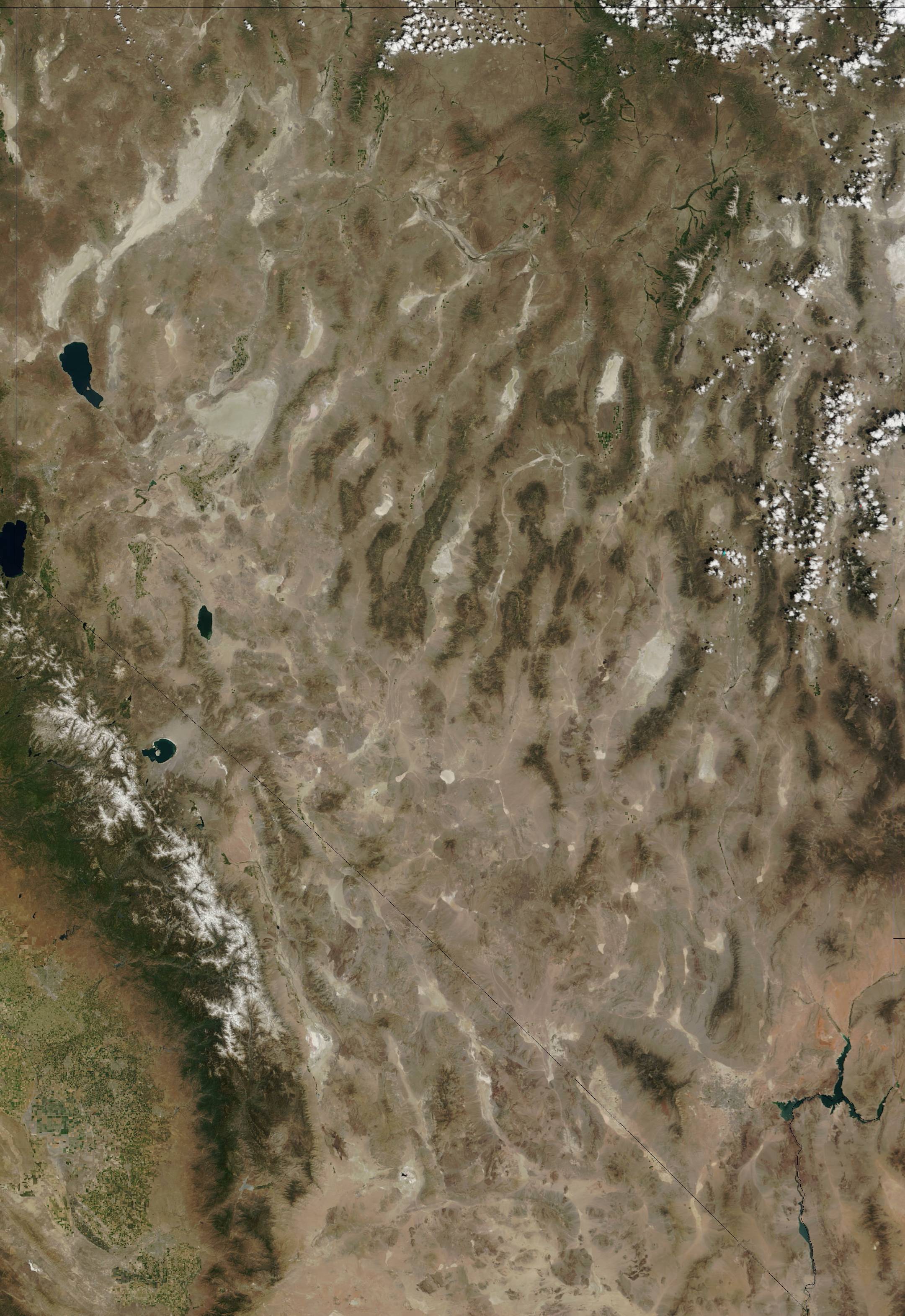
Various image processing, Landsat, Aster, and digital elevation model (DEM) projects. False color composite image of the area covered by the Reno 1 by 2 degree quadrangle. This image was created from 1992 MSS data. Nevada as observed from the MODIS satellite. This 2002 image was obtained from NASA. A 1990 USGS Shaded Relief Map of Nevada with color-coded elevations.
Mineral Tables, for the determination and identification of minerals by their physical properties, by Arthur S. Eakle, 1907, Large 29 megabyte pdf file size. Click here for compressed file version.
Geologic Map of Nevada, 1978, 1:500,000 scale, by J.H. Stewart and J.E. Carlson, USGS, in PDF file format. Georeferenced version in TIFFw format, UTM NAD27 Zone 11 projection, zip compressed file.
USGS Topographic Map of Nevada, 1:500,000 scale, in PDF file format. Georeferenced version in TIFFw format, UTM NAD27 Zone 11 projection, zip compressed file.
Individual USGS 1:100,000 scale topographic maps of Nevada in TIFFw Digital Raster Graphic format. These same maps covering the entire State, with map collar information removed (clipped) so they will print edge-to-edge without gaps, can be downloaded in one large zip compressed file (280 Mb) called nevada_clipped_drgs.zip. These digital maps are in TIFFw format, UTM NAD27 Zone 11 projection.
Land status map of Nevada, 2nd ed., 1972.
Historic, 1960, USGS Topographic Map Index of Nevada, showing existing older USGS 7.5 minute, 15 minute, 30 minute, and 1 degree map names and outlines. Newer index from 1984, USGS Topographic Maps of Nevada, showing more USGS 7.5 minute, 15 minute, and 1 degree map names and outlines. More current index from 1997, Primary Series 1:24,000 Scale Topographic Map Index of Nevada, showing only USGS 7.5 minute map names and outlines.
USGS Topographic Map Index of California, 1970, showing older USGS 7.5 minute and 15 minute map names and outlines.
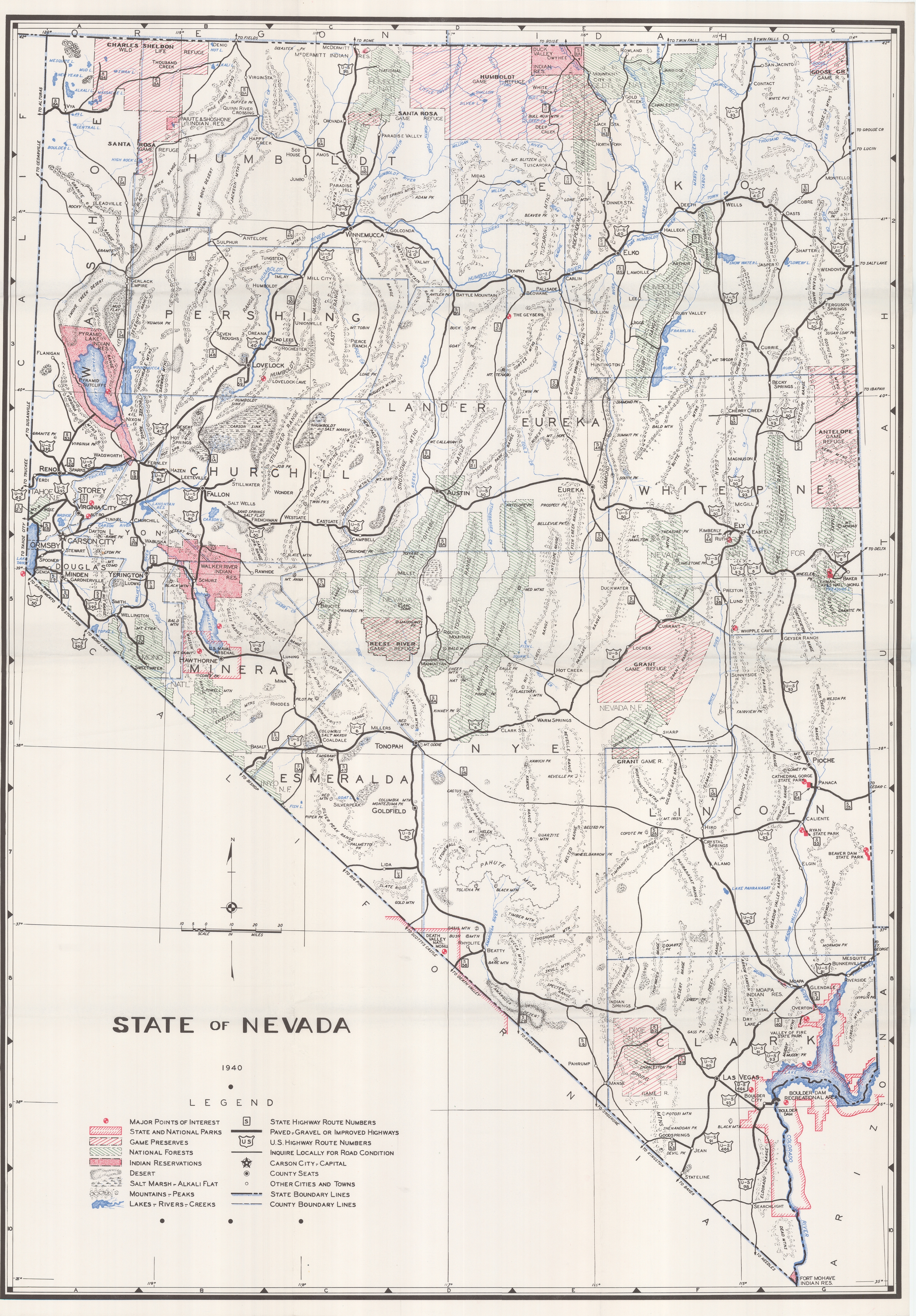
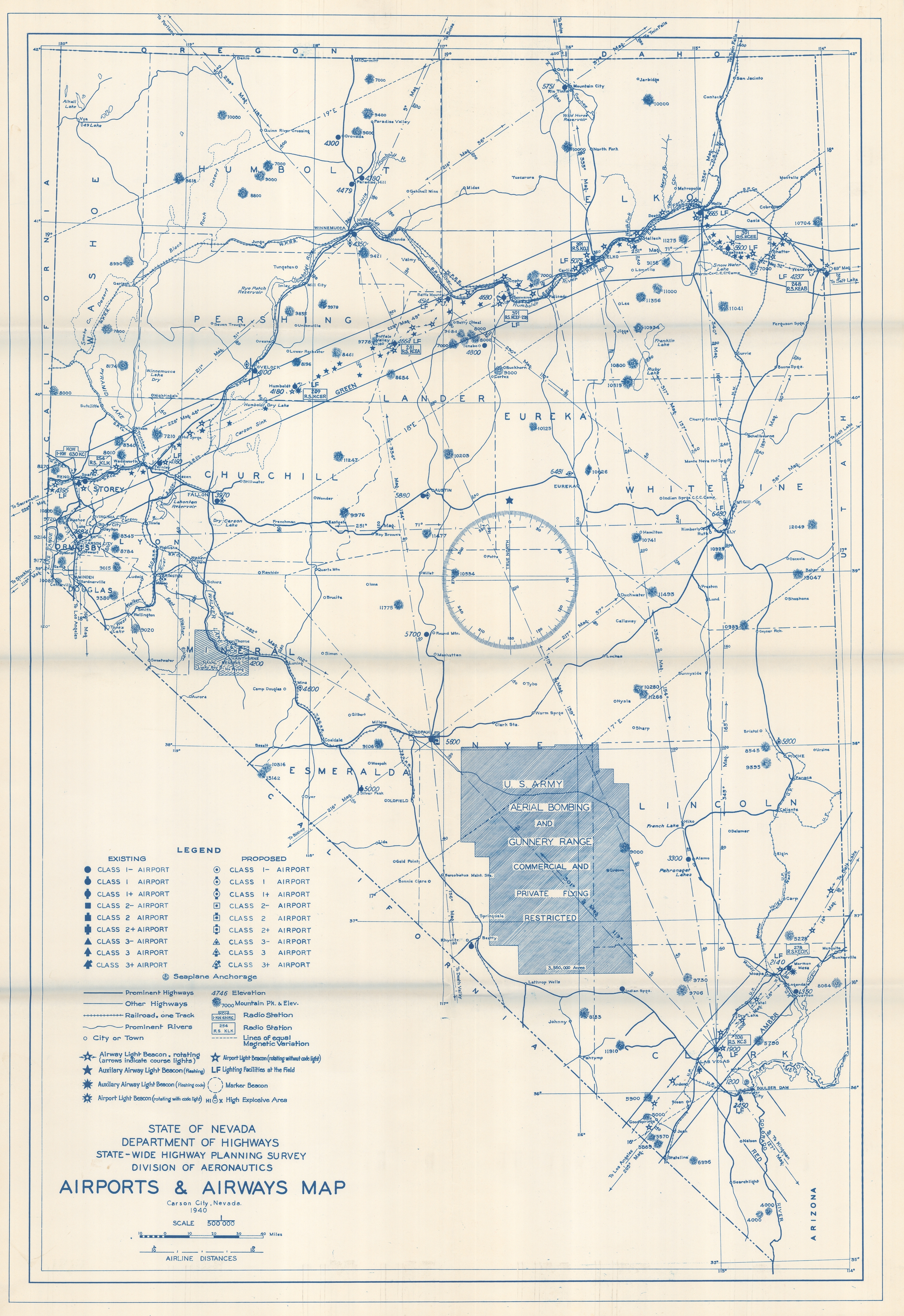
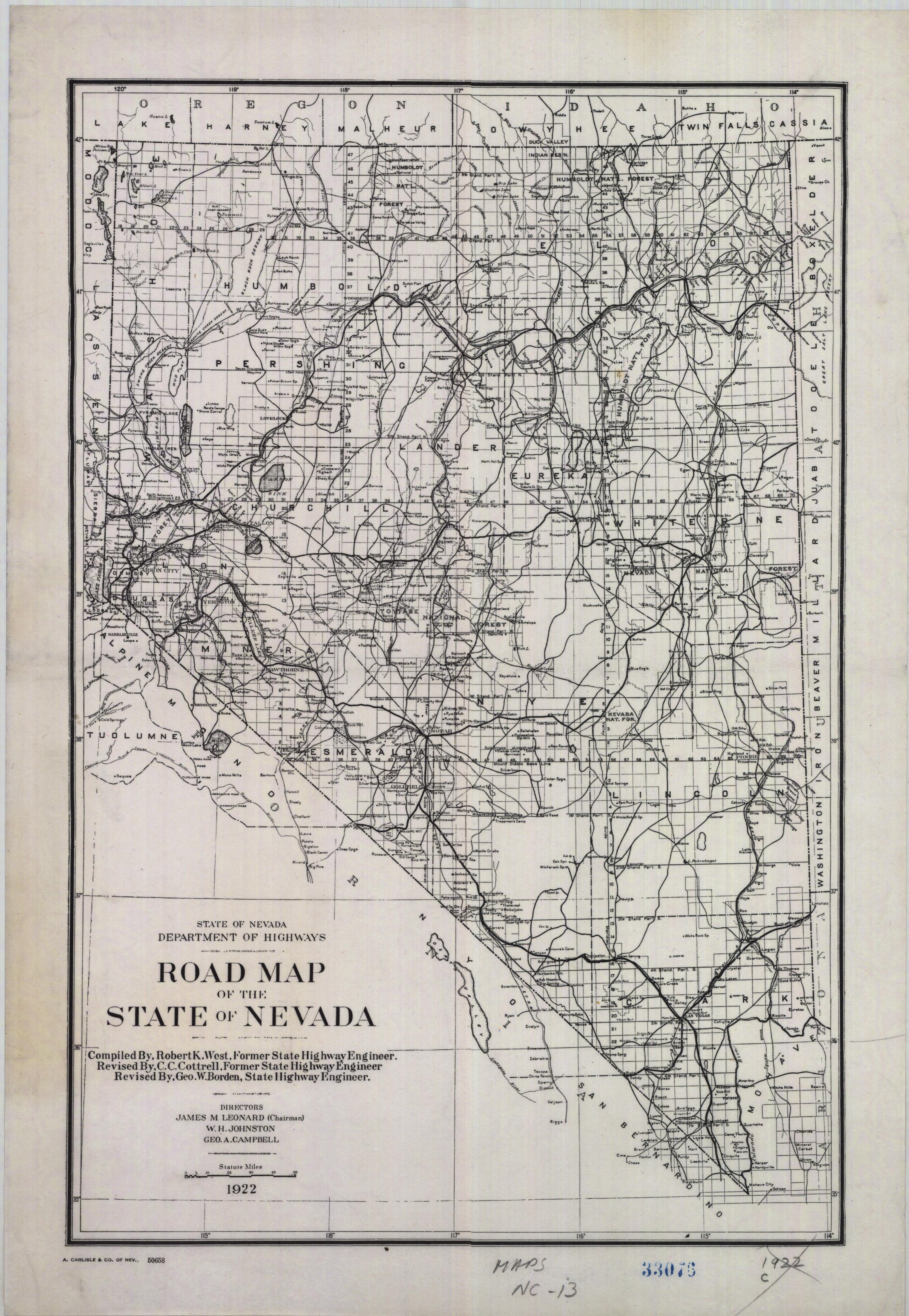
Map of the State of Nevada - 1940 and Airways Map of Nevada - 1940. Both digital copies are in JPEG format. The original copies of these maps are located at the Nevada Historical Society, Reno, Nevada. Early road maps of the State of Nevada, 1922 in jpeg file format and 1919 in pdf file format. Historic 1868 Map of California and Nevada. This is a large, 22 megabyte, jpeg file. 1871 Atlas Map of Nevada and California, in jpeg file format.
New Digital Geologic Map of Nevada: 2007, USGS Data Series 249 by A. Elizabeth Jones Crafford and others. Two components of this map represent new information that has not been published in this form before. The new geology layer was created by merging into a single file individual digital Nevada County geologic maps from "Hess and Johnson, 1996, County Digital Mapping Project, Nevada Bureau of Mines and Geology, Open-File Report 97-1", available online as a large zip file - 134 Mb. The original county geologic maps were published at a scale of 1:250,000. A new regional interpretation was created to unify all of the different county rock units, and then appropriate edits and modifications were made to the file to reflect additional geologic information and more current geologic interpretations.
For additional information I can be reached via email at rhess@ronhess.info .
| Ron Hess Home Page | Projects | Professional Summary | Active Mines Map |